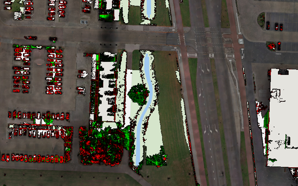
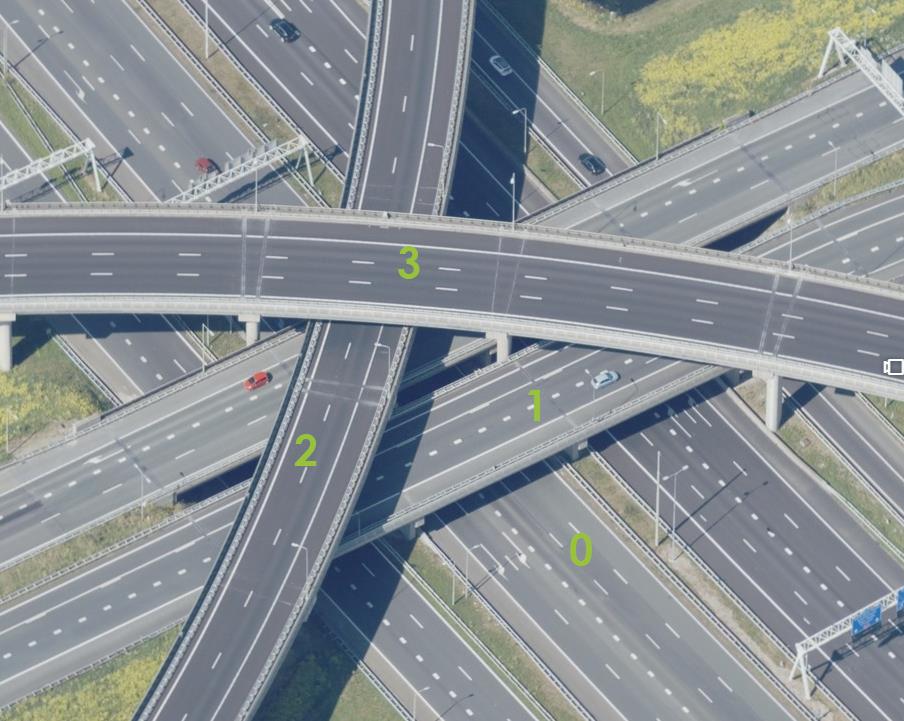
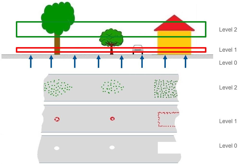
Street Ortho Service

Street Ortho is aerial imagery created based on street-level Cycloramas. By using the Street Ortho Service, you can show this aerial imagery in your own mapping application (GIS). The service is available as a Tile Map Service (TMS).

Note: Street Ortho is available on request for regions where Cyloramas are available.

Picture

Obtain credentials

Before you can start using the Street Ortho Service, you need to have credentials. If you do not have them yet, please use this form to request access.

Request your credentials
Picture

Read the documentation

Everything you need to know about the use of our Street Ortho Service can be found below in the Service Documentation.

Read the service documentation
Picture

View our examples

To help you getting started, we have created a set of code examples for you. You can use them as a basis for your own service requests.

Explore the code examples

Service Documentation


Figure 1: Example of a location where four base layers are available (0-3).


Figure 2: Illustration of the three height levels of Street Ortho imagery.

Understanding Street Ortho Service

Street Ortho images are like aerial ortho images, but then made from streel-level Cycloramas and street-level LiDAR data.

Base layer

Contrary to aerial ortho images, Street Ortho data can consist of multiple base layers on one location if there are roads that cross at different levels of elevation. Each level is referred to as a base layer. Figure 1 shows an example of a location where four different base layers will be available. You can specify the base layer of your choice in the TMS request, as explained in the service documentation below.

Height level

Street Ortho imagery consists of 3 height levels (see Figure 2).

  • Height (level) 0 – created out of point clouds with points maximum 30 centimeters above street level. The imagery is full color.

  • Height (level) 1 – created out of point clouds with points minimum of 30 centimeters and a maximum of 3 meters above street level. The imagery is colored in red.

  • Height (level) 2 – created out of point clouds with points minimum 3 meters above street level. The imagery is colored in green.

Pyramid grid formats

As a Tile Map Service (TMS), all imagery is pre-rendered and stored as tiles in a pyramid grid format. Each tile is 256 x 256 pixels in size.

Two pyramids are supported, one for the Netherlands and one for the rest of the world.

For Street Ortho in the Netherlands we use the standard from Geonovum, which is based on the ‘Rijksdriehoekstelsel’ coordinate system (EPSG: 28992).

The Geonovum pyramid is defined as:

In all other countries, Street Ortho is provided in the Google Web Mercator standard which is based on coordinate system Web Mercator (EPSG: 3857).

The Google Web Mercator pyramid is defined as:

Layer names

Depending on the applicable pyramid and required base layer and height level, the following layer names are available:

For Geonovum:

straat_ortho_base_0_height_0
straat_ortho_base_0_height_1
straat_ortho_base_0_height_2
straat_ortho_base_1_height_0
straat_ortho_base_1_height_1
straat_ortho_base_1_height_2
straat_ortho_base_2_height_0
straat_ortho_base_2_height_1
straat_ortho_base_2_height_2
straat_ortho_base_3_height_0
straat_ortho_base_3_height_1
straat_ortho_base_3_height_2

For Google Web Mercator:

street_ortho_base_0_height_0
street_ortho_base_0_height_1
street_ortho_base_0_height_2
street_ortho_base_1_height_0
street_ortho_base_1_height_1
street_ortho_base_1_height_2
street_ortho_base_2_height_0
street_ortho_base_2_height_1
street_ortho_base_2_height_2

For WMS:

street_ortho_base_0_height_0
street_ortho_base_0_height_1
street_ortho_base_0_height_2
street_ortho_base_1_height_0
street_ortho_base_1_height_1
street_ortho_base_1_height_2
street_ortho_base_2_height_0
street_ortho_base_2_height_1
street_ortho_base_2_height_2

Operations and response

The end point can be created using the following rule.

{baseURL}/{layerName}/tiles/tile/pwecmstreetorthotiles/
{pyramidName}/h{baseValue}/f{heightValue}/{z}/{x}/{y}.png

The URL contains the following parameters:

{baseURL} 

https://atlasapi.cyclomedia.com/api/image/tms/layer, this is the same for all requests.

{layerName}

Name of the layer containing base and height parameter (see .

{pyramidName}

Pyramid definition: geonovum or googlewebmercator.

{baseValue}

The base layer: 0 or up.

{heightValue}

Reference to the height level: f=0 for level 0, f=2 for level 1, f=3 for level 2. Note that the f value is slightly different from the actual height level.

{z}/{x}/{y}

The zoom level, row of the grid, and column of the grid, respectively.

WMS

Another way to connect to the street ortho data is via a Web Map Service (WMS)

Version 1.1.0 and 1.3.0 are supported.

The WMS URL is https://atlasapi.cyclomedia.com/geodata/api/wms-sol

Security

The service is secured with a username and password using basic authentication. Customers can obtain such a password from Cyclomedia. You need to add basic authentication headers to each request.

Code examples

Note: you can use Postman to test our web services and try out the code examples below.

Retrieve a Street Ortho tile

Retrieve a Street Ortho tile in Germany.

Format and example request for a Street Ortho tile in Germany:

{baseURL}/{layerName}/tiles/tile/pwecmstreetorthotiles/
{pyramidName}/h{baseValue}/f{heightValue}/{z}/{x}/{y}.png
https://atlasapi.cyclomedia.com/image/streetortho/layer/street_ortho_base_0_height_0/tiles/tile/pwecmstreetorthotiles/googlewebmercator/h0/f0/19/273845/171173.png